ON THIS PAGE
Take the Survey
The County wants to know if you feel the proposed improvements will make walking, biking, and rolling to and from Lambert Road station more pleasant and easier! Please take a few minutes to complete a quick survey. If you have a comment about any of the improvements, please submit your comment here.
https://www.surveymonkey.com/r/P3PCYB2
What is the Lambert Road Metro Rail Station First-Last Mile Plan?
Metro is planning to extend the L Line (formerly called Metro Gold Line Eastside Extension) from its current ending point at Pomona and Atlantic Boulevard in East LA through the cities of Commerce, Montebello, Pico Rivera, Santa Fe Springs and Whittier. The project is currently undergoing environmental review.
There are seven stations planned, including the Lambert Road Station, which would serve the unincorporated County community of West-Whittier – Los Nietos, and Cities of Whittier and Santa Fe Springs.
The County of Los Angeles is developing a First-Last Mile Plan to improve access and the ease of pedestrians traveling to and from Lambert Road Station. Based on community opinions and engineering analysis, the Plan will identify needed improvements within a ½-mile walking radius and a 3-mile biking radius from the proposed Lambert Road Station.
The ½ mile walking radius around the future station includes parts of the City of Whittier and a small portion of the West Whittier-Los Nietos neighborhood. The biking radius also includes areas from Santa Fe Springs and Pico Rivera.
What is “First-Last Mile”?
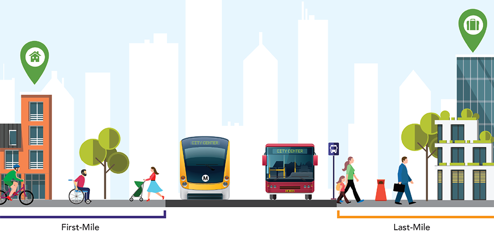
An individual’s trip is the entire journey from origin (such as their home) to destination (such as work or school). Individuals may use a number of types (modes) of transport to complete the journey – they may walk, drive, ride a bicycle, take a train, or – in many cases – combine a number of modes. Bus and rail services often form the core of a trip, but users complete the first and last portion on their own. For example, they must first walk, bike, drive or roll themselves to and from the nearest station. This is referred to as the first and last mile of the user’s trip.
What is the First-Last Mile Plan?
The Plan is an approach for identifying barriers to travel, such as access or accessibility concerns, and then planning and implementing improvements for the first-last mile (FLM) portions of an individual’s journey. All transit users must address the FLM challenge, and the easier and safer it is to access transit, the more likely people are to use it. An FLM Plan provides an adaptable way to address mobility improvements, and results in data and information to justify taking those actions for improved walking, biking, and rolling trips.
Examples of FLM improvements include the following:
- Infrastructure for more efficient walking, rolling, and biking (e.g. bike lanes, bike parking, sidewalks, and crosswalks)
- Shared use services (e.g. bike share and car share)
- Facilities for making modal connections (e.g. “kiss and ride” areas where passengers are dropped off at transit by friends or family, and bus/rail interface)
- Signage and wayfinding, and information and technology that eases travel (e.g. information kiosks and mobile apps)
Why is First-Last Mile Plan important?
First-last mile plans:
- Improve security and comfort for transit users of all ages and abilities
- Expand the transit experience so people are more likely to use transit
- Enhance visual aesthetics
- Encourage people to opt out of driving and decrease greenhouse gas emissions
What’s the timeline for the Lambert Road Metro Rail Station First-Last Mile Plan?
Public outreach began in 2020. Virtual community meetings and local walk audits in the area were held in 2021. The walk audits included small groups, with participants providing input on what would make key areas more comfortable for walking, rolling and biking. The Plan is expected to be completed in Spring 2023.
How can I get involved?
We are requesting public input on the proposed improvements and what the priorities should be for implementation. Share your observations and opinions that will help create a more accessible environment for pedestrians and bicyclists on their way to and from the proposed Lambert Road Metro Rail station to neighborhoods and key destinations. Your input will help to finalize the Plan.
Request to be added to the email list to stay informed or connect with First-Last Mile Plan team member Katherine Padilla by emailing kpadilla@katherinepadilla.com or calling 323.258.5384.
